
Click Data Catalogue to see the Data Sets you can display on the map view. They are organised into groups and sub-groups to make them easier to locate.

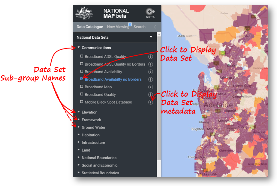
Click a Data Set Group Name (for example, National Data Sets) to see the Data Sets in that group.
Click a Data Set Sub-group Name (for example Communications) to see the Data Sets in that sub-group.
Click the check box to the left of the Data Set name to display that Data Set on the map. You can select as many as you like from any Group or Sub-group you like, but selecting too many will make for a very cluttered and confused display, and may make navigating in the Map View sluggish.
Click on the Data Set Name of any Data Set which you have already selected for display to cause the Map View to zoom to a view which just encloses all of the data in that Data Set. Data Sets which consist of a couple of small features on either side of the country may still be difficult to identify on the map. In this case you will need to zoom in manually to the correct location.
Click on the  button if any Data Set (even if it is not currently displayed) to show the available metadata
for that Data Set. The metadata includes the licence, which says what you can and can't do with the data.
button if any Data Set (even if it is not currently displayed) to show the available metadata
for that Data Set. The metadata includes the licence, which says what you can and can't do with the data.
To search for a particular Data Set, see the Search Tab.
The display of your Data Sets can be tuned using the Now Viewing Tab tab, which shows a legend of your selected Data Sets.