# Leaflet.PolylineMeasure
* Leaflet Plugin to :triangular_ruler: **measure distances** of simple lines as well as of complex polylines.
* Measuring in **metric system** (metre, kilometre), in **imperial system** (foot, landmile), or in **nautical miles**.
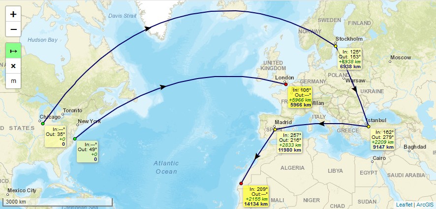
* lines are drawn as arcs and distances are calculated considering [Great.circle distance](https://en.wikipedia.org/wiki/Great-circle_distance) which is the shortest path between 2 points on Earth.
* To finish drawing a line just *doubleclick*, or *singleclick* onto the last (=orange) point, or *press "ESC"-key*.
* **Moving** of line's points afterwards is possible by clicking and draging them. *(This feature can not be guaranteed to work on every **mobile** browser using touch input, e.g. with Chrome Mobile it isn't working right now)*
* **Arrows** indicating the **real midways** of the line's great-circle **distances**, not their optical middle which is different due to projection, especially in high latitudes.
* It is an evolution of jtreml's Plugin [leaflet.measure](https://github.com/jtreml/leaflet.measure) since the original plugin hasn't been bugfixed for years. I modified it to work again with **Leaflet v1.0 and newer** (still runs with Leaflet v0.7) and added some optical improvements.
## Demos
* Please take a look at [**Demo 1**](https://ppete2.github.io/Leaflet.PolylineMeasure/demo1.html) (metre units, with Clear-button and Units-button) or [**Demo 2**](https://ppete2.github.io/Leaflet.PolylineMeasure/demo2.html) (landmile units, without Unit-button) or [**Demo 3**](https://ppete2.github.io/Leaflet.PolylineMeasure/demo3.html) (nauticalmile units, without Unit-button and Clear-button)
## Usage
Add 2 code lines within your **HTML-file** to load the .css and .js files of the plugin:
```html
```
Add 1 code line within your **Javascript-file** to add the plugin's control into your Leaflet map.
```js
L.control.polylineMeasure(options).addTo(map);
```
## Default options
```js
options = {
position: 'topleft', // Position to show the control. Possible values are: 'topright', 'topleft', 'bottomright', 'bottomleft'
unit: 'metres', // Show imperial or metric distances. Values: 'metres', 'landmiles', 'nauticalmiles'
measureControlTitleOn: 'Turn on PolylineMeasure', // Title for the control going to be switched on
measureControlTitleOff: 'Turn off PolylineMeasure', // Title for the control going to be switched off
measureControlLabel: '↦', // HTML to place inside the control
measureControlClasses: [], // Classes to apply to the control
backgroundColor: '#8f8', // Background color for control when selected
cursor: 'crosshair', // Cursor type to show when creating measurements
clearMeasurementsOnStop: true, // Clear all the measurements when the control is unselected
showMeasurementsClearControl: false, // Show a control to clear all the measurements
clearControlTitle: 'Clear Measurements',// Title text to show on the clear measurements control button
clearControlLabel: '×', // Clear control inner html
clearControlClasses: [], // Collection of classes to add to clear control button
showUnitControl: false, // Show a control to change the units of measurements
tempLine: { // Styling settings for the temporary dashed line
color: '#00f', // Dashed line color
weight: 2 // Dashed line weight
},
fixedLine: { // Styling for the solid line
color: '#006', // Solid line color
weight: 2 // Solid line weight
},
startCircle: { // Style settings for circle marker indicating the starting point of the polyline
color: '#000', // Color of the border of the circle
weight: 1, // Weight of the circle
fillColor: '#0f0', // Fill color of the circle
fillOpacity: 1, // Fill opacity of the circle
radius: 3 // Radius of the circle
},
intermedCircle: { // Style settings for all circle markers between startCircle and endCircle
color: '#000', // Color of the border of the circle
weight: 1, // Weight of the circle
fillColor: '#ff0', // Fill color of the circle
fillOpacity: 1, // Fill opacity of the circle
radius: 3 // Radius of the circle
},
currentCircle: { // Style settings for circle marker indicating the latest point of the polyline during drawing a line
color: '#000', // Color of the border of the circle
weight: 1, // Weight of the circle
fillColor: '#f0f', // Fill color of the circle
fillOpacity: 1, // Fill opacity of the circle
radius: 3 // Radius of the circle
},
endCircle: { // Style settings for circle marker indicating the last point of the polyline
color: '#000', // Color of the border of the circle
weight: 1, // Weight of the circle
fillColor: '#f00', // Fill color of the circle
fillOpacity: 1, // Fill opacity of the circle
radius: 3 // Radius of the circle
},
};
```