import type Extent from "./Extent.js";
import type BaseGeometry from "./Geometry.js";
import type Point from "./Point.js";
import type Polygon from "./Polygon.js";
import type MeshComponent from "./support/MeshComponent.js";
import type MeshTransform from "./support/MeshTransform.js";
import type MeshVertexAttributes from "./support/MeshVertexAttributes.js";
import type { ClonableMixin } from "../core/Clonable.js";
import type { LoadableMixin, LoadableMixinProperties } from "../core/Loadable.js";
import type { EsriPromiseMixin } from "../core/Promise.js";
import type { MeshVertexSpaceUnion } from "./types.js";
import type { MeshComponentProperties } from "./support/MeshComponent.js";
import type { MeshMaterialProperties } from "./support/MeshMaterial.js";
import type { CreateBoxParameters, CreateCylinderParameters, CreateSphereParameters, CreatePlaneParameters, RotateParameters, CenterAtParameters, ScaleParameters, CreateFromGLTFParameters, ExportGLTFOptions } from "./support/meshUtils/types.js";
import type { MeshLocalVertexSpaceProperties } from "./support/MeshLocalVertexSpace.js";
import type { MeshGeoreferencedVertexSpaceProperties } from "./support/MeshGeoreferencedVertexSpace.js";
import type { MeshTransformProperties } from "./support/MeshTransform.js";
import type { MeshVertexAttributesProperties } from "./support/MeshVertexAttributes.js";
import type { GeometryProperties as BaseGeometryProperties } from "./Geometry.js";
export interface MeshProperties extends BaseGeometryProperties, LoadableMixinProperties {
/**
* An array of mesh components that can be used to apply materials
* to different regions of the same mesh. There are three common
* usage patterns for components.
*
* 1. **Specify a material for the whole mesh.** In this case, use a single
* component with only a material (leaving faces as `null`).
* 2. **Reuse vertex attributes.** When modeling continuous surfaces,
* it can be convenient to only specify vertices once and then
* simply refer to them. In this case, use a single component
* with faces set to index the vertex attributes that form
* triangles.
* 3. **Specify multiple materials for the same mesh.** In this case,
* use multiple components with faces that determine to which region
* of the mesh the material of the component applies.
*/
components?: MeshComponentProperties[] | null;
/**
* Additional local transformation of the mesh vertices. The transform is ignored if the
* [vertexSpace](https://developers.arcgis.com/javascript/latest/references/core/geometry/Mesh/#vertexSpace)
* is of type [georeferenced](https://developers.arcgis.com/javascript/latest/references/core/geometry/support/MeshGeoreferencedVertexSpace/) and does not specify
* an [MeshGeoreferencedVertexSpace.origin](https://developers.arcgis.com/javascript/latest/references/core/geometry/support/MeshGeoreferencedVertexSpace/#origin).
*/
transform?: MeshTransformProperties | null;
/**
* Object describing the attributes of each vertex of the mesh. Vertex attributes
* are flat numerical arrays that describe the position (mandatory), normal (used for
* lighting calculations and shading) and UV (used for mapping material images to the
* mesh surface) for each vertex.
*
* Vertex attributes can be addressed by indices specified in the components
* [MeshComponent.faces](https://developers.arcgis.com/javascript/latest/references/core/geometry/support/MeshComponent/#faces) property. If the
* mesh does not contain any components, or if a component does not specify any faces,
* then the vertex attributes are interpreted as if each consecutive vertex triple
* makes up a triangle.
*
* @example
* let mesh = new Mesh({ spatialReference: SpatialReference.WebMercator });
*
* // Specify vertices for two triangles that make up a square
* // around a provided point. UV coordinates are set up to cover the square
* // from (0, 0) to (1, 1) from corner to corner.
* mesh.vertexAttributes = {
* position: [
* pt.x - 10, pt.y - 10, 100,
* pt.x + 10, pt.y - 10, 100,
* pt.x + 10, pt.y + 10, 100,
*
* pt.x - 10, pt.y - 10, 100,
* pt.x + 10, pt.y + 10, 100,
* pt.x - 10, pt.y + 10, 100
* ],
* uv: [
* 0, 0,
* 1, 0,
* 1, 1,
*
* 0, 0,
* 1, 1,
* 0, 1
* ]
* };
*/
vertexAttributes?: MeshVertexAttributesProperties;
/**
* Defines how the SDK interprets the x, y, z position values stored in
* [Mesh.vertexAttributes.position](https://developers.arcgis.com/javascript/latest/references/core/geometry/support/MeshVertexAttributes/#position).
*
* A source 3D model or custom vertex buffer usually stores positions as numbers, but those numbers do not indicate by
* themselves whether they are local model coordinates, offsets from a placement point, or absolute map coordinates.
* This property makes that interpretation explicit for the Mesh geometry.
*
* Use [MeshLocalVertexSpace](https://developers.arcgis.com/javascript/latest/references/core/geometry/support/MeshLocalVertexSpace/) when the position values are meter-based local model coordinates
* and should be placed in a global [SceneView](https://developers.arcgis.com/javascript/latest/references/core/views/SceneView/). Use
* [MeshGeoreferencedVertexSpace](https://developers.arcgis.com/javascript/latest/references/core/geometry/support/MeshGeoreferencedVertexSpace/) when the position values should be interpreted as offsets or
* absolute coordinates in the coordinate system identified by
* [Mesh.spatialReference](https://developers.arcgis.com/javascript/latest/references/core/geometry/Mesh/#spatialReference), which is the usual choice for local scenes with a
* projected coordinate system.
*
* This property is construct-only because changing it changes the meaning of every vertex position in the mesh.
* To change the vertex space of an existing mesh, use [convertVertexSpace()](https://developers.arcgis.com/javascript/latest/references/core/geometry/support/meshUtils/#convertVertexSpace).
*/
vertexSpace?: ((MeshGeoreferencedVertexSpaceProperties & { type: "georeferenced" }) | (MeshLocalVertexSpaceProperties & { type: "local" }));
}
/**
* ## Overview
*
* In general 3D terminology, a mesh is a set of vertices connected into faces that define the shape and surface of a
* 3D object. In the Maps SDK, a Mesh instance is a [Geometry](https://developers.arcgis.com/javascript/latest/references/core/geometry/Geometry/) that stores those vertices in
* [vertexAttributes](https://developers.arcgis.com/javascript/latest/references/core/geometry/Mesh/#vertexAttributes).
*
* The [position](https://developers.arcgis.com/javascript/latest/references/core/geometry/support/MeshVertexAttributes/#position) values define the shape of the 3D object,
* [normals](https://developers.arcgis.com/javascript/latest/references/core/geometry/support/MeshVertexAttributes/#normal) affect lighting and shading, and
* [UV coordinates](https://developers.arcgis.com/javascript/latest/references/core/geometry/support/MeshVertexAttributes/#uv) can be used to map images to the surface.
* [Mesh components](https://developers.arcgis.com/javascript/latest/references/core/geometry/support/MeshComponent/) define triangle faces and can assign materials to different
* regions of the Mesh geometry. Because faces index into the vertex attributes, components can reuse the same vertices
* instead of duplicating them for every triangle.
*
* Mesh geometries can define intrinsic materials. Similar to 3D objects in scene layers, they are symbolized with a
* [MeshSymbol3D](https://developers.arcgis.com/javascript/latest/references/core/symbols/MeshSymbol3D/) symbol containing a [FillSymbol3DLayer](https://developers.arcgis.com/javascript/latest/references/core/symbols/FillSymbol3DLayer/). The fill symbol layer renders
* the mesh surface and can define visual overrides such as material, color, and edges.
*
* Meshes returned from remote services, such as through [SceneLayer.queryFeatures()](https://developers.arcgis.com/javascript/latest/references/core/layers/SceneLayer/#queryFeatures), may need to load
* their content asynchronously. When a Mesh is added to a view through a [Graphic](https://developers.arcgis.com/javascript/latest/references/core/Graphic/), the API loads it as needed
* for display. Call [load()](https://developers.arcgis.com/javascript/latest/references/core/geometry/Mesh/#load) before accessing properties such as
* [vertexAttributes](https://developers.arcgis.com/javascript/latest/references/core/geometry/Mesh/#vertexAttributes), [extent](https://developers.arcgis.com/javascript/latest/references/core/geometry/Mesh/#extent), and [components](https://developers.arcgis.com/javascript/latest/references/core/geometry/Mesh/#components) directly
* when the mesh is not yet loaded.
*
* ## Mesh georeferencing
*
* A source 3D model file, imported model, or custom vertex buffer often stores vertex positions as plain x, y, z
* numbers. Those numbers do not, by themselves, say whether [10, 0, 0] means ten meters east of the source model's
* own [0, 0, 0], ten map units east of a provided placement point in a projected coordinate system (PCS), or an absolute
* coordinate on a map. Some formats (e.g., IFC4) and workflows include georeferencing metadata, but a Mesh instance still needs
* an explicit interpretation of the position values stored in [MeshVertexAttributes.position](https://developers.arcgis.com/javascript/latest/references/core/geometry/support/MeshVertexAttributes/#position).
*
* The [vertexSpace](https://developers.arcgis.com/javascript/latest/references/core/geometry/Mesh/#vertexSpace) property provides this interpretation. It specifies whether
* the position values are coordinates relative to the model's own origin, offsets from an specific origin you provide,
* or absolute map coordinates.
*
* To georeference a Mesh geometry:
*
* 1. Note the [SceneView.viewingMode](https://developers.arcgis.com/javascript/latest/references/core/views/SceneView/#viewingMode) you are using. A "global" scene and a
* "local" scene require different Mesh configurations to work correctly and efficiently.
* 2. Set [Mesh.spatialReference](https://developers.arcgis.com/javascript/latest/references/core/geometry/Mesh/#spatialReference) to a coordinate system compatible with that
* [viewingMode](https://developers.arcgis.com/javascript/latest/references/core/views/SceneView/#viewingMode).
* 3. Choose [Mesh.vertexSpace](https://developers.arcgis.com/javascript/latest/references/core/geometry/Mesh/#vertexSpace) based on both the
* [viewingMode](https://developers.arcgis.com/javascript/latest/references/core/views/SceneView/#viewingMode) and what the source x, y, z values mean.
* 4. Provide an origin only when the source x, y, z values are offsets from a placement point, such as the source model's
* own [0, 0, 0] or an insertion point. The origin is stored on the selected vertex space:
* [local](https://developers.arcgis.com/javascript/latest/references/core/geometry/support/MeshLocalVertexSpace/#origin) or
* [georeferenced](https://developers.arcgis.com/javascript/latest/references/core/geometry/support/MeshGeoreferencedVertexSpace/#origin).
*
* ### Common georeferencing workflows
*
* The common workflows below show how to choose a vertex space for source values that are measured from [0, 0, 0],
* offsets from a placement point, or absolute map coordinates.
*
* - In a [global](https://developers.arcgis.com/javascript/latest/references/core/views/SceneView/#viewingMode) view, use [MeshLocalVertexSpace](https://developers.arcgis.com/javascript/latest/references/core/geometry/support/MeshLocalVertexSpace/).
* This is common for models whose x, y, z positions describe the object relative to the model's own [0, 0, 0],
* such as models from 3D modeling or CAD tools. Set [Mesh.spatialReference](https://developers.arcgis.com/javascript/latest/references/core/geometry/Mesh/#spatialReference)
* to a geographic coordinate system, such as WGS84 or CGCS2000, or to Web Mercator, and set
* [MeshLocalVertexSpace.origin](https://developers.arcgis.com/javascript/latest/references/core/geometry/support/MeshLocalVertexSpace/#origin) to the coordinate where the model's [0, 0, 0] should land.
* - In a [local](https://developers.arcgis.com/javascript/latest/references/core/views/SceneView/#viewingMode) view, use [MeshGeoreferencedVertexSpace](https://developers.arcgis.com/javascript/latest/references/core/geometry/support/MeshGeoreferencedVertexSpace/) with
* an [MeshGeoreferencedVertexSpace.origin](https://developers.arcgis.com/javascript/latest/references/core/geometry/support/MeshGeoreferencedVertexSpace/#origin). This works for both source data whose x, y, z
* values are offsets from a placement point, and for models whose x, y, z positions describe the object relative to
* the model's own [0, 0, 0]. Set [Mesh.spatialReference](https://developers.arcgis.com/javascript/latest/references/core/geometry/Mesh/#spatialReference) to the same projected
* coordinate system as [SceneView.spatialReference](https://developers.arcgis.com/javascript/latest/references/core/views/SceneView/#spatialReference). The SDK then treats each x, y, z position as an
* offset from the origin in the projected coordinate system used by the view.
* - To use source data whose x, y, z positions were already exported as coordinates in a projected coordinate system,
* use [MeshGeoreferencedVertexSpace](https://developers.arcgis.com/javascript/latest/references/core/geometry/support/MeshGeoreferencedVertexSpace/) without an origin. Set
* [Mesh.spatialReference](https://developers.arcgis.com/javascript/latest/references/core/geometry/Mesh/#spatialReference) to that projected coordinate system. Each x, y, z
* position is then interpreted as an absolute coordinate in that coordinate system.
* - When you create primitives or import glTF with [meshUtils](https://developers.arcgis.com/javascript/latest/references/core/geometry/support/meshUtils/) create functions and do not
* provide a vertex space, the SDK chooses one from the provided location. It chooses
* [MeshLocalVertexSpace](https://developers.arcgis.com/javascript/latest/references/core/geometry/support/MeshLocalVertexSpace/) when the location's spatial reference is geographic, such as WGS84
* or CGCS2000, or when it is Web Mercator. It chooses [MeshGeoreferencedVertexSpace](https://developers.arcgis.com/javascript/latest/references/core/geometry/support/MeshGeoreferencedVertexSpace/) for
* other projected coordinate systems. This is a helpful default; choose the vertex space explicitly when your view
* setup or data workflow requires a different interpretation.
*
*
* Read More
*
*
*
* ### Local vertex space
*
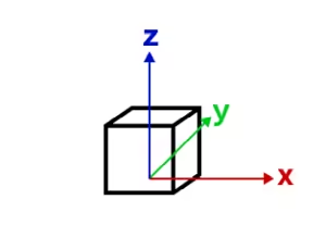
* In a [local vertex space](https://developers.arcgis.com/javascript/latest/references/core/geometry/support/MeshLocalVertexSpace/), the
* [MeshVertexAttributes.position](https://developers.arcgis.com/javascript/latest/references/core/geometry/support/MeshVertexAttributes/#position) values are model coordinates in meters, measured from the
* source model's local [0, 0, 0]. The [MeshLocalVertexSpace.origin](https://developers.arcgis.com/javascript/latest/references/core/geometry/support/MeshLocalVertexSpace/#origin) places that local origin
* at an [x, y, z] coordinate in the coordinate system identified by
* [Mesh.spatialReference](https://developers.arcgis.com/javascript/latest/references/core/geometry/Mesh/#spatialReference).
*
*  *
* *local vertex space*
*
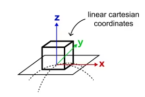
* When a Mesh geometry with [MeshLocalVertexSpace](https://developers.arcgis.com/javascript/latest/references/core/geometry/support/MeshLocalVertexSpace/) is displayed in a global scene and
* [Mesh.spatialReference](https://developers.arcgis.com/javascript/latest/references/core/geometry/Mesh/#spatialReference) is WGS84, CGCS2000, or Web Mercator, the SDK places the
* local coordinate frame on the globe at [MeshLocalVertexSpace.origin](https://developers.arcgis.com/javascript/latest/references/core/geometry/support/MeshLocalVertexSpace/#origin). The frame is aligned to
* the [local tangent plane](https://en.wikipedia.org/wiki/Local_tangent_plane_coordinates): X points east, Y points
* north, and Z points up. This is commonly called an east, north, up (ENU) frame.
*
*
*
* *local vertex space*
*
* When a Mesh geometry with [MeshLocalVertexSpace](https://developers.arcgis.com/javascript/latest/references/core/geometry/support/MeshLocalVertexSpace/) is displayed in a global scene and
* [Mesh.spatialReference](https://developers.arcgis.com/javascript/latest/references/core/geometry/Mesh/#spatialReference) is WGS84, CGCS2000, or Web Mercator, the SDK places the
* local coordinate frame on the globe at [MeshLocalVertexSpace.origin](https://developers.arcgis.com/javascript/latest/references/core/geometry/support/MeshLocalVertexSpace/#origin). The frame is aligned to
* the [local tangent plane](https://en.wikipedia.org/wiki/Local_tangent_plane_coordinates): X points east, Y points
* north, and Z points up. This is commonly called an east, north, up (ENU) frame.
*
*  *
* *local vertex space aligned to the sphere's tangent plane at the origin point*
*
* This reference-frame approach is an approximation: it uses a spherical tangent plane matching how global scenes
* are rendered. The farther a vertex is from
* [MeshLocalVertexSpace.origin](https://developers.arcgis.com/javascript/latest/references/core/geometry/support/MeshLocalVertexSpace/#origin), the more the local tangent plane diverges from the curved
* surface. This is usually acceptable for buildings and other models that occupy a limited area, but it is not
* appropriate for long objects that must follow the earth's curvature.
*
* The word "local" in [MeshLocalVertexSpace](https://developers.arcgis.com/javascript/latest/references/core/geometry/support/MeshLocalVertexSpace/) refers to coordinates from the source model
* measured from that model's own [0, 0, 0]. It does not mean that this vertex space is the right choice for a
* [local](https://developers.arcgis.com/javascript/latest/references/core/views/SceneView/#viewingMode) view. For mesh graphics in a local view, use
* [MeshGeoreferencedVertexSpace](https://developers.arcgis.com/javascript/latest/references/core/geometry/support/MeshGeoreferencedVertexSpace/) in the view's projected coordinate system.
*
* ### Georeferenced vertex space
*
* [Mesh.vertexSpace](https://developers.arcgis.com/javascript/latest/references/core/geometry/Mesh/#vertexSpace) gives meaning to the source x, y, z values stored in
* [MeshVertexAttributes.position](https://developers.arcgis.com/javascript/latest/references/core/geometry/support/MeshVertexAttributes/#position). A
* [georeferenced vertex space](https://developers.arcgis.com/javascript/latest/references/core/geometry/support/MeshGeoreferencedVertexSpace/) interprets those numbers in relation
* to [Mesh.spatialReference](https://developers.arcgis.com/javascript/latest/references/core/geometry/Mesh/#spatialReference), either as offsets from a placement point or as
* absolute map coordinates.
*
* - When the [origin](https://developers.arcgis.com/javascript/latest/references/core/geometry/support/MeshGeoreferencedVertexSpace/#origin) is set, the mesh's vertex coordinates
* are interpreted as offsets from that origin. This works well for 3D models created by CAD software whose x, y and z
* values are measured from the source model's own [0, 0, 0], and for those measured from a specific insertion point.
* The origin is the [x, y, z] coordinate, in the Mesh's
* [spatialReference](https://developers.arcgis.com/javascript/latest/references/core/geometry/Mesh/#spatialReference), where that local [0, 0, 0] or insertion point lands.
* The offset directions and units come from [Mesh.spatialReference](https://developers.arcgis.com/javascript/latest/references/core/geometry/Mesh/#spatialReference). In a
* projected coordinate system, these are usually map units such as meters.
* - Without an [origin](https://developers.arcgis.com/javascript/latest/references/core/geometry/support/MeshGeoreferencedVertexSpace/#origin), use this vertex space
* when the source x, y, z values are already absolute map coordinates, for example a mesh produced from a LiDAR scan,
* photogrammetry reconstruction, or surveyed surface and exported in a projected coordinate system. Each source
* position is used directly in [Mesh.spatialReference](https://developers.arcgis.com/javascript/latest/references/core/geometry/Mesh/#spatialReference).
*
*
*
* *local vertex space aligned to the sphere's tangent plane at the origin point*
*
* This reference-frame approach is an approximation: it uses a spherical tangent plane matching how global scenes
* are rendered. The farther a vertex is from
* [MeshLocalVertexSpace.origin](https://developers.arcgis.com/javascript/latest/references/core/geometry/support/MeshLocalVertexSpace/#origin), the more the local tangent plane diverges from the curved
* surface. This is usually acceptable for buildings and other models that occupy a limited area, but it is not
* appropriate for long objects that must follow the earth's curvature.
*
* The word "local" in [MeshLocalVertexSpace](https://developers.arcgis.com/javascript/latest/references/core/geometry/support/MeshLocalVertexSpace/) refers to coordinates from the source model
* measured from that model's own [0, 0, 0]. It does not mean that this vertex space is the right choice for a
* [local](https://developers.arcgis.com/javascript/latest/references/core/views/SceneView/#viewingMode) view. For mesh graphics in a local view, use
* [MeshGeoreferencedVertexSpace](https://developers.arcgis.com/javascript/latest/references/core/geometry/support/MeshGeoreferencedVertexSpace/) in the view's projected coordinate system.
*
* ### Georeferenced vertex space
*
* [Mesh.vertexSpace](https://developers.arcgis.com/javascript/latest/references/core/geometry/Mesh/#vertexSpace) gives meaning to the source x, y, z values stored in
* [MeshVertexAttributes.position](https://developers.arcgis.com/javascript/latest/references/core/geometry/support/MeshVertexAttributes/#position). A
* [georeferenced vertex space](https://developers.arcgis.com/javascript/latest/references/core/geometry/support/MeshGeoreferencedVertexSpace/) interprets those numbers in relation
* to [Mesh.spatialReference](https://developers.arcgis.com/javascript/latest/references/core/geometry/Mesh/#spatialReference), either as offsets from a placement point or as
* absolute map coordinates.
*
* - When the [origin](https://developers.arcgis.com/javascript/latest/references/core/geometry/support/MeshGeoreferencedVertexSpace/#origin) is set, the mesh's vertex coordinates
* are interpreted as offsets from that origin. This works well for 3D models created by CAD software whose x, y and z
* values are measured from the source model's own [0, 0, 0], and for those measured from a specific insertion point.
* The origin is the [x, y, z] coordinate, in the Mesh's
* [spatialReference](https://developers.arcgis.com/javascript/latest/references/core/geometry/Mesh/#spatialReference), where that local [0, 0, 0] or insertion point lands.
* The offset directions and units come from [Mesh.spatialReference](https://developers.arcgis.com/javascript/latest/references/core/geometry/Mesh/#spatialReference). In a
* projected coordinate system, these are usually map units such as meters.
* - Without an [origin](https://developers.arcgis.com/javascript/latest/references/core/geometry/support/MeshGeoreferencedVertexSpace/#origin), use this vertex space
* when the source x, y, z values are already absolute map coordinates, for example a mesh produced from a LiDAR scan,
* photogrammetry reconstruction, or surveyed surface and exported in a projected coordinate system. Each source
* position is used directly in [Mesh.spatialReference](https://developers.arcgis.com/javascript/latest/references/core/geometry/Mesh/#spatialReference).
*
*  *
* *georeferenced vertex space on a projected coordinate system*
*
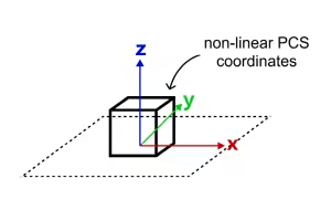
* A georeferenced vertex space is the usual choice for mesh graphics in local scenes. Use it when the
* [view spatial reference](https://developers.arcgis.com/javascript/latest/references/core/views/SceneView/#spatialReference) is a projected coordinate system and
* [Mesh.spatialReference](https://developers.arcgis.com/javascript/latest/references/core/geometry/Mesh/#spatialReference) uses the same projected coordinate system. In that
* configuration, the position values and the view use the same projected coordinate space, so display and editing can
* be efficient and predictable.
*
* > [!WARNING]
* > Do not use a georeferenced vertex space with a
* > [vertex space origin](https://developers.arcgis.com/javascript/latest/references/core/geometry/support/MeshGeoreferencedVertexSpace/#origin) in WGS84 or CGCS2000 for source
* > models whose x, y, z values are measured in meters. In those geographic coordinate systems, longitude and latitude
* > are angular coordinates, so an offset such as [10, 0, 0] means ten degrees of longitude, not ten meters east.
* > A building model can appear at the wrong size or far from the intended location. If the source model is measured in
* > meters and should be placed on the globe, use [MeshLocalVertexSpace](https://developers.arcgis.com/javascript/latest/references/core/geometry/support/MeshLocalVertexSpace/) instead.
*
* ### Web Mercator
*
* Web Mercator is a projected coordinate system, but it is treated specially in global scenes because of its central
* role in web mapping. A Mesh geometry whose [Mesh.spatialReference](https://developers.arcgis.com/javascript/latest/references/core/geometry/Mesh/#spatialReference) is Web
* Mercator can use
* [MeshLocalVertexSpace](https://developers.arcgis.com/javascript/latest/references/core/geometry/support/MeshLocalVertexSpace/) in a global [SceneView](https://developers.arcgis.com/javascript/latest/references/core/views/SceneView/). Other projected coordinate
* systems should use a local [SceneView](https://developers.arcgis.com/javascript/latest/references/core/views/SceneView/) and [MeshGeoreferencedVertexSpace](https://developers.arcgis.com/javascript/latest/references/core/geometry/support/MeshGeoreferencedVertexSpace/).
*
* Web Mercator is not recommended as the spatial reference for local scenes or for publishing 3D object layers that
* require accurate local dimensions. Web Mercator map units are distorted: one Web Mercator meter equals one ground
* meter only near the equator, and the scale variation increases with latitude. For local scenes and 3D object layer
* workflows, prefer a projected coordinate system designed for the area of interest.
*
* ### Troubleshooting mesh georeferencing
*
* If a mesh graphic is not displayed, or is displayed in the wrong place or at the wrong size, first check the browser
* console for warnings. Then narrow the problem in this order:
*
* 1. Start with [SceneView.viewingMode](https://developers.arcgis.com/javascript/latest/references/core/views/SceneView/#viewingMode). In a global SceneView, the usual choice for model files whose
* positions are measured from the model's own [0, 0, 0] is [MeshLocalVertexSpace](https://developers.arcgis.com/javascript/latest/references/core/geometry/support/MeshLocalVertexSpace/). In a
* local SceneView, the usual choice is [MeshGeoreferencedVertexSpace](https://developers.arcgis.com/javascript/latest/references/core/geometry/support/MeshGeoreferencedVertexSpace/) with a projected
* [Mesh.spatialReference](https://developers.arcgis.com/javascript/latest/references/core/geometry/Mesh/#spatialReference) that matches
* [SceneView.spatialReference](https://developers.arcgis.com/javascript/latest/references/core/views/SceneView/#spatialReference).
* 2. Identify what the source model's x, y, z values mean. They may be local model coordinates measured from
* [0, 0, 0], offsets from an insertion point, or absolute coordinates exported by a georeferenced workflow.
* 3. Check the vertex space's origin when it has one. The origin should be the [x, y, z] coordinate where the source
* model's [0, 0, 0] or insertion point should land, using the coordinate system identified by
* [Mesh.spatialReference](https://developers.arcgis.com/javascript/latest/references/core/geometry/Mesh/#spatialReference).
* 4. Check units. [MeshLocalVertexSpace](https://developers.arcgis.com/javascript/latest/references/core/geometry/support/MeshLocalVertexSpace/) interprets position values as meters.
* [MeshGeoreferencedVertexSpace](https://developers.arcgis.com/javascript/latest/references/core/geometry/support/MeshGeoreferencedVertexSpace/) with a vertex space origin interprets offsets in the units
* of [Mesh.spatialReference](https://developers.arcgis.com/javascript/latest/references/core/geometry/Mesh/#spatialReference).
*
*
* ### Limitations
*
* - [MeshLocalVertexSpace](https://developers.arcgis.com/javascript/latest/references/core/geometry/support/MeshLocalVertexSpace/) is not supported for mesh graphics displayed in a local
* [SceneView](https://developers.arcgis.com/javascript/latest/references/core/views/SceneView/).
* - Displaying or editing a Mesh geometry can be unsupported when
* [Mesh.spatialReference](https://developers.arcgis.com/javascript/latest/references/core/geometry/Mesh/#spatialReference),
* [SceneView.spatialReference](https://developers.arcgis.com/javascript/latest/references/core/views/SceneView/#spatialReference), and
* [Mesh.vertexSpace](https://developers.arcgis.com/javascript/latest/references/core/geometry/Mesh/#vertexSpace) would require costly or unavailable per-vertex projection.
* - For 3D object feature editing workflows that use Mesh geometry, see the
* [SceneLayer](https://developers.arcgis.com/javascript/latest/references/core/layers/SceneLayer/) editing documentation and
* [3D object workflows in the SDK](https://developers.arcgis.com/javascript/latest/3d-object-workflows/#essential-aspects-of-the-editing-workflow).
*
*
*
* *georeferenced vertex space on a projected coordinate system*
*
* A georeferenced vertex space is the usual choice for mesh graphics in local scenes. Use it when the
* [view spatial reference](https://developers.arcgis.com/javascript/latest/references/core/views/SceneView/#spatialReference) is a projected coordinate system and
* [Mesh.spatialReference](https://developers.arcgis.com/javascript/latest/references/core/geometry/Mesh/#spatialReference) uses the same projected coordinate system. In that
* configuration, the position values and the view use the same projected coordinate space, so display and editing can
* be efficient and predictable.
*
* > [!WARNING]
* > Do not use a georeferenced vertex space with a
* > [vertex space origin](https://developers.arcgis.com/javascript/latest/references/core/geometry/support/MeshGeoreferencedVertexSpace/#origin) in WGS84 or CGCS2000 for source
* > models whose x, y, z values are measured in meters. In those geographic coordinate systems, longitude and latitude
* > are angular coordinates, so an offset such as [10, 0, 0] means ten degrees of longitude, not ten meters east.
* > A building model can appear at the wrong size or far from the intended location. If the source model is measured in
* > meters and should be placed on the globe, use [MeshLocalVertexSpace](https://developers.arcgis.com/javascript/latest/references/core/geometry/support/MeshLocalVertexSpace/) instead.
*
* ### Web Mercator
*
* Web Mercator is a projected coordinate system, but it is treated specially in global scenes because of its central
* role in web mapping. A Mesh geometry whose [Mesh.spatialReference](https://developers.arcgis.com/javascript/latest/references/core/geometry/Mesh/#spatialReference) is Web
* Mercator can use
* [MeshLocalVertexSpace](https://developers.arcgis.com/javascript/latest/references/core/geometry/support/MeshLocalVertexSpace/) in a global [SceneView](https://developers.arcgis.com/javascript/latest/references/core/views/SceneView/). Other projected coordinate
* systems should use a local [SceneView](https://developers.arcgis.com/javascript/latest/references/core/views/SceneView/) and [MeshGeoreferencedVertexSpace](https://developers.arcgis.com/javascript/latest/references/core/geometry/support/MeshGeoreferencedVertexSpace/).
*
* Web Mercator is not recommended as the spatial reference for local scenes or for publishing 3D object layers that
* require accurate local dimensions. Web Mercator map units are distorted: one Web Mercator meter equals one ground
* meter only near the equator, and the scale variation increases with latitude. For local scenes and 3D object layer
* workflows, prefer a projected coordinate system designed for the area of interest.
*
* ### Troubleshooting mesh georeferencing
*
* If a mesh graphic is not displayed, or is displayed in the wrong place or at the wrong size, first check the browser
* console for warnings. Then narrow the problem in this order:
*
* 1. Start with [SceneView.viewingMode](https://developers.arcgis.com/javascript/latest/references/core/views/SceneView/#viewingMode). In a global SceneView, the usual choice for model files whose
* positions are measured from the model's own [0, 0, 0] is [MeshLocalVertexSpace](https://developers.arcgis.com/javascript/latest/references/core/geometry/support/MeshLocalVertexSpace/). In a
* local SceneView, the usual choice is [MeshGeoreferencedVertexSpace](https://developers.arcgis.com/javascript/latest/references/core/geometry/support/MeshGeoreferencedVertexSpace/) with a projected
* [Mesh.spatialReference](https://developers.arcgis.com/javascript/latest/references/core/geometry/Mesh/#spatialReference) that matches
* [SceneView.spatialReference](https://developers.arcgis.com/javascript/latest/references/core/views/SceneView/#spatialReference).
* 2. Identify what the source model's x, y, z values mean. They may be local model coordinates measured from
* [0, 0, 0], offsets from an insertion point, or absolute coordinates exported by a georeferenced workflow.
* 3. Check the vertex space's origin when it has one. The origin should be the [x, y, z] coordinate where the source
* model's [0, 0, 0] or insertion point should land, using the coordinate system identified by
* [Mesh.spatialReference](https://developers.arcgis.com/javascript/latest/references/core/geometry/Mesh/#spatialReference).
* 4. Check units. [MeshLocalVertexSpace](https://developers.arcgis.com/javascript/latest/references/core/geometry/support/MeshLocalVertexSpace/) interprets position values as meters.
* [MeshGeoreferencedVertexSpace](https://developers.arcgis.com/javascript/latest/references/core/geometry/support/MeshGeoreferencedVertexSpace/) with a vertex space origin interprets offsets in the units
* of [Mesh.spatialReference](https://developers.arcgis.com/javascript/latest/references/core/geometry/Mesh/#spatialReference).
*
*
* ### Limitations
*
* - [MeshLocalVertexSpace](https://developers.arcgis.com/javascript/latest/references/core/geometry/support/MeshLocalVertexSpace/) is not supported for mesh graphics displayed in a local
* [SceneView](https://developers.arcgis.com/javascript/latest/references/core/views/SceneView/).
* - Displaying or editing a Mesh geometry can be unsupported when
* [Mesh.spatialReference](https://developers.arcgis.com/javascript/latest/references/core/geometry/Mesh/#spatialReference),
* [SceneView.spatialReference](https://developers.arcgis.com/javascript/latest/references/core/views/SceneView/#spatialReference), and
* [Mesh.vertexSpace](https://developers.arcgis.com/javascript/latest/references/core/geometry/Mesh/#vertexSpace) would require costly or unavailable per-vertex projection.
* - For 3D object feature editing workflows that use Mesh geometry, see the
* [SceneLayer](https://developers.arcgis.com/javascript/latest/references/core/layers/SceneLayer/) editing documentation and
* [3D object workflows in the SDK](https://developers.arcgis.com/javascript/latest/3d-object-workflows/#essential-aspects-of-the-editing-workflow).
*
*
*
* ---
*
* ## Create simple mesh geometry primitives
*
* There are a couple of convenience functions in [meshUtils](https://developers.arcgis.com/javascript/latest/references/core/geometry/support/meshUtils/) to create simple
* primitive shapes. These shapes can help you get started with understanding
* mesh geometries.
*
* ```js
* // Create a box mesh geometry
* let mesh = meshUtils.createBox(location, {
* size: {
* width: 100,
* height: 50,
* depth: 50
* },
* material: {
* color: "red"
* }
* });
*
* // Create a graphic and add it to the view
* let graphic = new Graphic({
* geometry: mesh,
* symbol: {
* type: "mesh-3d",
* symbolLayers: [ { type: "fill" } ]
* }
* });
*
* view.graphics.add(graphic);
* ```
*
* ---
*
* ## Create mesh geometries manually
*
* Mesh geometries can be manually created by specifying [vertexAttributes](https://developers.arcgis.com/javascript/latest/references/core/geometry/Mesh/#vertexAttributes) and
* [components](https://developers.arcgis.com/javascript/latest/references/core/geometry/Mesh/#components) like in the following example:
*
* ```js
* // Create a mesh geometry representing a pyramid
* let pyramidMesh = new Mesh({
* vertexAttributes: {
* // vertex positions for the Louvre pyramid, Paris
* position: [
* // vertex 0 - base of the pyramid, south
* 2.336006, 48.860818, 0,
*
* // vertex 1 - base of the pyramid, east
* 2.336172, 48.861114, 0,
*
* // vertex 2 - base of the pyramid, north
* 2.335724, 48.861229, 0,
*
* // vertex 3 - base of the pyramid, west
* 2.335563, 48.860922, 0,
*
* // vertex 4 - top of the pyramid
* 2.335896, 48.861024, 21
* ]
* },
* // Add a single component with faces that index the vertices
* // so we only need to define them once
* components: [
* {
* faces: [
* 0, 4, 3,
* 0, 1, 4,
* 1, 2, 4,
* 2, 3, 4
* ]
* }
* ],
* // specify a spatial reference if the position of the vertices is not in WGS84
* });
*
* // add the mesh geometry to a graphic
* let graphic = new Graphic({
* geometry: pyramidMesh,
* symbol: {
* type: "mesh-3d",
* symbolLayers: [ { type: "fill" } ]
* }
* });
*
* view.graphics.add(graphic);
* ```
*
* **Note:** Starting with version 4.11 autocasting is no longer supported for Mesh geometry.
*
* @since 4.7
* @see [MeshComponent](https://developers.arcgis.com/javascript/latest/references/core/geometry/support/MeshComponent/)
* @see [meshUtils](https://developers.arcgis.com/javascript/latest/references/core/geometry/support/meshUtils/)
* @see [Sample - Working with 3d mesh primitives](https://developers.arcgis.com/javascript/latest/sample-code/geometry-mesh-primitives/)
* @see [Sample - Low poly terrain using mesh geometry](https://developers.arcgis.com/javascript/latest/sample-code/geometry-mesh-elevation/)
*/
export default class Mesh extends MeshSuperclass {
/**
* Creates a mesh representing a box. The spatial reference of the resulting mesh is the same
* as the location where it is placed.
*
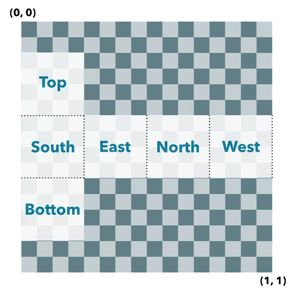
* #### Box UV coordinate space
*
* The box geometry will have UV coordinates generated according to the following scheme:
*
*  *
* @deprecated since version 5.1. Use [createBox()](https://developers.arcgis.com/javascript/latest/references/core/geometry/support/meshUtils/#createBox) instead.
* @param location - The location bottom center of the box.
* @param parameters - Parameters to configure the box creation.
* @returns The resulting mesh.
* @example
* let mesh = Mesh.createBox(point, {
* size: {
* width: 10,
* height: 100,
* depth: 20
* },
* material: {
* color: "green"
* }
* });
* @example
* let mesh = Mesh.createBox(point, {
* imageFace: "top",
* material: {
* colorTexture: new MeshTexture({ url: "./url-to-image.png" })
* }
* });
*/
static createBox(location: Point, parameters?: CreateBoxParameters): Mesh;
/**
* Creates a mesh representing a cylinder. The spatial reference of the resulting mesh is the same
* as the location where it is placed.
*
* #### Cylinder UV coordinate space
*
* The cylinder geometry will have UV coordinates generated according to the following scheme
* (example is shown for 8 vertices cylinder):
*
*
*
* @deprecated since version 5.1. Use [createBox()](https://developers.arcgis.com/javascript/latest/references/core/geometry/support/meshUtils/#createBox) instead.
* @param location - The location bottom center of the box.
* @param parameters - Parameters to configure the box creation.
* @returns The resulting mesh.
* @example
* let mesh = Mesh.createBox(point, {
* size: {
* width: 10,
* height: 100,
* depth: 20
* },
* material: {
* color: "green"
* }
* });
* @example
* let mesh = Mesh.createBox(point, {
* imageFace: "top",
* material: {
* colorTexture: new MeshTexture({ url: "./url-to-image.png" })
* }
* });
*/
static createBox(location: Point, parameters?: CreateBoxParameters): Mesh;
/**
* Creates a mesh representing a cylinder. The spatial reference of the resulting mesh is the same
* as the location where it is placed.
*
* #### Cylinder UV coordinate space
*
* The cylinder geometry will have UV coordinates generated according to the following scheme
* (example is shown for 8 vertices cylinder):
*
* 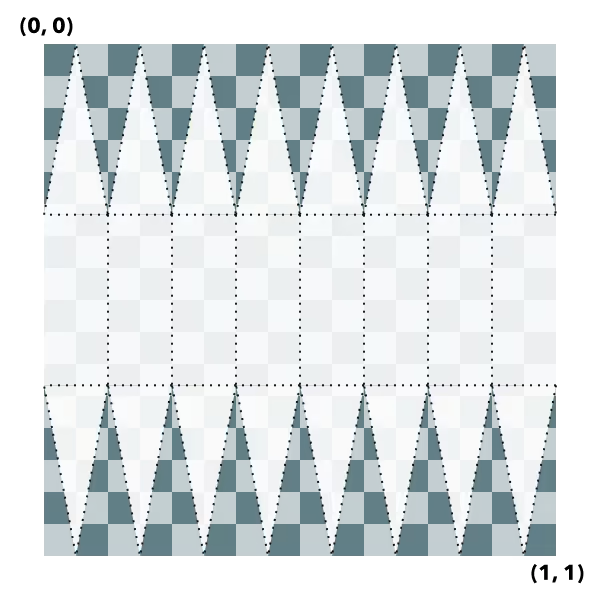 *
* @deprecated since version 5.1. Use [createCylinder()](https://developers.arcgis.com/javascript/latest/references/core/geometry/support/meshUtils/#createCylinder) instead.
* @param location - The location of the bottom center of the cylinder.
* @param parameters - Parameters to configure the cylinder creation.
* @returns The resulting mesh.
*/
static createCylinder(location: Point, parameters?: CreateCylinderParameters): Mesh;
/**
* Creates a new mesh geometry from a glTF model referenced by the `url` parameter.
*
* The spatial reference of the resulting mesh is the same as the spatial reference of the `location` parameter. For
* more information on the supported glTF features you can read the
* [Visualizing points with 3D symbols](https://developers.arcgis.com/javascript/latest/visualizing-points-3d/) guide topic. Animations are currently unsupported.
*
* @deprecated since version 5.1. Use [createFromGLTF()](https://developers.arcgis.com/javascript/latest/references/core/geometry/support/meshUtils/#createFromGLTF) instead.
* @param location - The location of the origin of the model. If the location does not
* contain a z-value, z is assumed to be `0`.
* @param url - The URL of the glTF model. The URL should point to a glTF file (.gltf or .glb) which can
* reference additional binary (.bin) and image files (.jpg, .png).
* @param parameters - Parameters to configure the mesh from glTF creation.
* @returns A promise that resolves to a mesh geometry representing the loaded
* glTF model.
* @since 4.11
*/
static createFromGLTF(location: Point, url: string, parameters?: CreateFromGLTFParameters): Promise;
/**
* Creates a new mesh geometry from a polygon geometry. The resulting mesh contains only
* a position vertex attribute and a single component with faces. The default shading will be
* set to `flat`. The spatial reference of the resulting mesh is the same
* as the input polygon. The resulting mesh will not contain any UV nor normal vertex attributes.
*
* @deprecated since version 5.1. Use [createFromPolygon()](https://developers.arcgis.com/javascript/latest/references/core/geometry/support/meshUtils/#createFromPolygon) instead.
* @param polygon - The input polygon.
* @param parameters - Optional parameters.
* @returns A new mesh representing the triangulated polygon.
*/
static createFromPolygon(polygon: Polygon, parameters?: CreateFromPolygonParameters): Mesh;
/**
* Creates a mesh representing a plane. The spatial reference of the resulting mesh is the same
* as the location where it is placed. A plane consists of two triangles and may be conveniently
* oriented at creation time.
*
* #### Plane UV coordinate space
*
* The plane geometry will have UV coordinates generated according to the following scheme:
*
*
*
* @deprecated since version 5.1. Use [createCylinder()](https://developers.arcgis.com/javascript/latest/references/core/geometry/support/meshUtils/#createCylinder) instead.
* @param location - The location of the bottom center of the cylinder.
* @param parameters - Parameters to configure the cylinder creation.
* @returns The resulting mesh.
*/
static createCylinder(location: Point, parameters?: CreateCylinderParameters): Mesh;
/**
* Creates a new mesh geometry from a glTF model referenced by the `url` parameter.
*
* The spatial reference of the resulting mesh is the same as the spatial reference of the `location` parameter. For
* more information on the supported glTF features you can read the
* [Visualizing points with 3D symbols](https://developers.arcgis.com/javascript/latest/visualizing-points-3d/) guide topic. Animations are currently unsupported.
*
* @deprecated since version 5.1. Use [createFromGLTF()](https://developers.arcgis.com/javascript/latest/references/core/geometry/support/meshUtils/#createFromGLTF) instead.
* @param location - The location of the origin of the model. If the location does not
* contain a z-value, z is assumed to be `0`.
* @param url - The URL of the glTF model. The URL should point to a glTF file (.gltf or .glb) which can
* reference additional binary (.bin) and image files (.jpg, .png).
* @param parameters - Parameters to configure the mesh from glTF creation.
* @returns A promise that resolves to a mesh geometry representing the loaded
* glTF model.
* @since 4.11
*/
static createFromGLTF(location: Point, url: string, parameters?: CreateFromGLTFParameters): Promise;
/**
* Creates a new mesh geometry from a polygon geometry. The resulting mesh contains only
* a position vertex attribute and a single component with faces. The default shading will be
* set to `flat`. The spatial reference of the resulting mesh is the same
* as the input polygon. The resulting mesh will not contain any UV nor normal vertex attributes.
*
* @deprecated since version 5.1. Use [createFromPolygon()](https://developers.arcgis.com/javascript/latest/references/core/geometry/support/meshUtils/#createFromPolygon) instead.
* @param polygon - The input polygon.
* @param parameters - Optional parameters.
* @returns A new mesh representing the triangulated polygon.
*/
static createFromPolygon(polygon: Polygon, parameters?: CreateFromPolygonParameters): Mesh;
/**
* Creates a mesh representing a plane. The spatial reference of the resulting mesh is the same
* as the location where it is placed. A plane consists of two triangles and may be conveniently
* oriented at creation time.
*
* #### Plane UV coordinate space
*
* The plane geometry will have UV coordinates generated according to the following scheme:
*
*  *
* @deprecated since version 5.1. Use [createPlane()](https://developers.arcgis.com/javascript/latest/references/core/geometry/support/meshUtils/#createPlane) instead.
* @param location - The location of the bottom center of the plane.
* @param parameters - Parameters to configure the plane creation.
* @returns The resulting mesh.
*/
static createPlane(location: Point, parameters?: CreatePlaneParameters): Mesh;
/**
* Creates a mesh representing a sphere. The spatial reference of the resulting mesh is the same
* as the location where it is placed.
*
* #### Sphere UV coordinate space
*
* The sphere geometry will have UV coordinates generated according to the following scheme
* (example is shown for 8x8 vertices sphere):
*
*
*
* @deprecated since version 5.1. Use [createPlane()](https://developers.arcgis.com/javascript/latest/references/core/geometry/support/meshUtils/#createPlane) instead.
* @param location - The location of the bottom center of the plane.
* @param parameters - Parameters to configure the plane creation.
* @returns The resulting mesh.
*/
static createPlane(location: Point, parameters?: CreatePlaneParameters): Mesh;
/**
* Creates a mesh representing a sphere. The spatial reference of the resulting mesh is the same
* as the location where it is placed.
*
* #### Sphere UV coordinate space
*
* The sphere geometry will have UV coordinates generated according to the following scheme
* (example is shown for 8x8 vertices sphere):
*
* 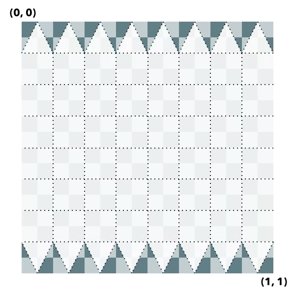 *
* @deprecated since version 5.1. Use [createSphere()](https://developers.arcgis.com/javascript/latest/references/core/geometry/support/meshUtils/#createSphere) instead.
* @param location - The location of the bottom center of the sphere.
* @param parameters - Parameters to configure the sphere creation.
* @returns The resulting mesh.
*/
static createSphere(location: Point, parameters?: CreateSphereParameters): Mesh;
constructor(properties?: MeshProperties);
/**
* An array of mesh components that can be used to apply materials
* to different regions of the same mesh. There are three common
* usage patterns for components.
*
* 1. **Specify a material for the whole mesh.** In this case, use a single
* component with only a material (leaving faces as `null`).
* 2. **Reuse vertex attributes.** When modeling continuous surfaces,
* it can be convenient to only specify vertices once and then
* simply refer to them. In this case, use a single component
* with faces set to index the vertex attributes that form
* triangles.
* 3. **Specify multiple materials for the same mesh.** In this case,
* use multiple components with faces that determine to which region
* of the mesh the material of the component applies.
*/
get components(): MeshComponent[] | null | undefined;
set components(value: MeshComponentProperties[] | null | undefined);
/**
* The 3D extent of the mesh geometry. The extent is computed from the
* vertex positions stored in the [vertexAttributes](https://developers.arcgis.com/javascript/latest/references/core/geometry/Mesh/#vertexAttributes).
* The 3D extent is computed on-demand and cached. If you modify the
* vertexAttributes manually, then you must call
* [vertexAttributesChanged()](https://developers.arcgis.com/javascript/latest/references/core/geometry/Mesh/#vertexAttributesChanged) to make sure the
* extent will be recomputed.
*/
get extent(): Extent;
/**
* The origin of the mesh. This corresponds to the vertex space origin for relative vertex spaces.
* For absolute vertex spaces, the origin is at the bottom of the mesh.
*
* @since 4.30
*/
get origin(): Point;
/**
* Additional local transformation of the mesh vertices. The transform is ignored if the
* [vertexSpace](https://developers.arcgis.com/javascript/latest/references/core/geometry/Mesh/#vertexSpace)
* is of type [georeferenced](https://developers.arcgis.com/javascript/latest/references/core/geometry/support/MeshGeoreferencedVertexSpace/) and does not specify
* an [MeshGeoreferencedVertexSpace.origin](https://developers.arcgis.com/javascript/latest/references/core/geometry/support/MeshGeoreferencedVertexSpace/#origin).
*/
get transform(): MeshTransform | null | undefined;
set transform(value: MeshTransformProperties | null | undefined);
/** The string value representing the type of geometry. */
get type(): "mesh";
/**
* Object describing the attributes of each vertex of the mesh. Vertex attributes
* are flat numerical arrays that describe the position (mandatory), normal (used for
* lighting calculations and shading) and UV (used for mapping material images to the
* mesh surface) for each vertex.
*
* Vertex attributes can be addressed by indices specified in the components
* [MeshComponent.faces](https://developers.arcgis.com/javascript/latest/references/core/geometry/support/MeshComponent/#faces) property. If the
* mesh does not contain any components, or if a component does not specify any faces,
* then the vertex attributes are interpreted as if each consecutive vertex triple
* makes up a triangle.
*
* @example
* let mesh = new Mesh({ spatialReference: SpatialReference.WebMercator });
*
* // Specify vertices for two triangles that make up a square
* // around a provided point. UV coordinates are set up to cover the square
* // from (0, 0) to (1, 1) from corner to corner.
* mesh.vertexAttributes = {
* position: [
* pt.x - 10, pt.y - 10, 100,
* pt.x + 10, pt.y - 10, 100,
* pt.x + 10, pt.y + 10, 100,
*
* pt.x - 10, pt.y - 10, 100,
* pt.x + 10, pt.y + 10, 100,
* pt.x - 10, pt.y + 10, 100
* ],
* uv: [
* 0, 0,
* 1, 0,
* 1, 1,
*
* 0, 0,
* 1, 1,
* 0, 1
* ]
* };
*/
get vertexAttributes(): MeshVertexAttributes;
set vertexAttributes(value: MeshVertexAttributesProperties);
/**
* Defines how the SDK interprets the x, y, z position values stored in
* [Mesh.vertexAttributes.position](https://developers.arcgis.com/javascript/latest/references/core/geometry/support/MeshVertexAttributes/#position).
*
* A source 3D model or custom vertex buffer usually stores positions as numbers, but those numbers do not indicate by
* themselves whether they are local model coordinates, offsets from a placement point, or absolute map coordinates.
* This property makes that interpretation explicit for the Mesh geometry.
*
* Use [MeshLocalVertexSpace](https://developers.arcgis.com/javascript/latest/references/core/geometry/support/MeshLocalVertexSpace/) when the position values are meter-based local model coordinates
* and should be placed in a global [SceneView](https://developers.arcgis.com/javascript/latest/references/core/views/SceneView/). Use
* [MeshGeoreferencedVertexSpace](https://developers.arcgis.com/javascript/latest/references/core/geometry/support/MeshGeoreferencedVertexSpace/) when the position values should be interpreted as offsets or
* absolute coordinates in the coordinate system identified by
* [Mesh.spatialReference](https://developers.arcgis.com/javascript/latest/references/core/geometry/Mesh/#spatialReference), which is the usual choice for local scenes with a
* projected coordinate system.
*
* This property is construct-only because changing it changes the meaning of every vertex position in the mesh.
* To change the vertex space of an existing mesh, use [convertVertexSpace()](https://developers.arcgis.com/javascript/latest/references/core/geometry/support/meshUtils/#convertVertexSpace).
*/
get vertexSpace(): MeshVertexSpaceUnion;
/**
* Adds a component to the mesh.
*
* @param component - The component to add.
*/
addComponent(component: MeshComponentProperties): void;
/**
* Centers the mesh at the specified location without changing its scale. This effectively adjusts the mesh
* origin and mesh vertices such that vertices are given relative to the new location and the new location
* is the new origin. The effective georeferenced vertex positions will not change.
*
* The mesh will be modified in place. To modify a copy of the mesh instead, use [clone()](https://developers.arcgis.com/javascript/latest/references/core/geometry/Mesh/#clone)
* before calling [centerAt()](https://developers.arcgis.com/javascript/latest/references/core/geometry/Mesh/#centerAt).
*
* @param location - The location at which to center the mesh.
* @param parameters - Additional parameters.
* @returns The modified mesh.
*/
centerAt(location: Point, parameters?: CenterAtParameters): this;
/**
* Creates a deep clone of the Mesh object.
*
* @returns A new instance of a Mesh object equal to the object used to call `.clone()`.
*/
clone(): this;
/**
* Offsets the mesh geometry by the specified distance in x, y, and z. The units of x, y, and z are the
* units of the spatial reference. When the vertex space is local or georeferenced with an origin,
* the offset is applied to the origin of the vertex space. When the vertex space is georeferenced
* without origin, the offset is applied to the vertex positions directly.
*
* The mesh will be modified in place. To modify a copy of the mesh instead, use [clone()](https://developers.arcgis.com/javascript/latest/references/core/geometry/Mesh/#clone)
* before calling [offset()](https://developers.arcgis.com/javascript/latest/references/core/geometry/Mesh/#offset).
*
* @param dx - The amount to offset the geometry in the x direction.
* @param dy - The amount to offset the geometry in the y direction.
* @param dz - The amount to offset the geometry in the z direction.
* @returns The modified mesh (this instance).
*/
offset(dx: number, dy: number, dz: number): this;
/**
* Removes a component from the mesh.
*
* @param component - The component to remove.
*/
removeComponent(component: MeshComponent): void;
/**
* Rotates the mesh geometry around its x, y and z axis (in that order). For each rotation angle,
* the rotation direction is clockwise when looking in the direction of the respective axis.
* The mesh will be modified in place. To modify a copy of the mesh instead, use [clone()](https://developers.arcgis.com/javascript/latest/references/core/geometry/Mesh/#clone)
* before calling [rotate()](https://developers.arcgis.com/javascript/latest/references/core/geometry/Mesh/#rotate).
*
* @param angleX - The angle by which to rotate around the x-axis (in degrees).
* @param angleY - The angle by which to rotate around the y-axis (in degrees).
* @param angleZ - The angle by which to rotate around the z-axis (in degrees).
* @param parameters - Additional parameters.
* @returns The modified mesh (this instance).
* @example
* // rotate the mesh in the horizontal plane (around the z axis) by 90 degrees and tilt it in the lateral
* // vertical plane (around the y axis) by 20 degrees.
* mesh.rotate(0, 20, 90);
*/
rotate(angleX: number, angleY: number, angleZ: number, parameters?: RotateParameters): this;
/**
* Scales the mesh geometry by the specified factor. The mesh will be modified in place.
* To modify a copy of the mesh instead, use [clone()](https://developers.arcgis.com/javascript/latest/references/core/geometry/Mesh/#clone) before calling [scale()](https://developers.arcgis.com/javascript/latest/references/core/geometry/Mesh/#scale).
*
* @param factor - The amount to scale the geometry.
* @param parameters - Additional parameters.
* @returns The modified mesh (this instance).
*/
scale(factor: number, parameters?: ScaleParameters): this;
/**
* Export a mesh to a binary glTF (glb) representation. The resulting ArrayBuffer could be uploaded
* to a service or give an application the option to download a representation of the mesh.
*
* @param options - Additional options.
* @returns The binary glTF data.
* @since 4.30
* @example
* function downloadBufferAsFile(filename, buffer, type) {
* const objectUrl = URL.createObjectURL(new Blob([buffer], { type }));
*
* const a = document.createElement("a");
* a.download = filename;
* a.href = objectUrl;
* a.style.display = "none";
*
* document.body.appendChild(a);
* a.click();
*
* document.body.removeChild(a);
* URL.revokeObjectURL(objectUrl);
* }
*
* const buffer = await mesh.toBinaryGLTF();
* downloadBufferAsFile("model.glb", buffer, "model/gltf-binary");
*/
toBinaryGLTF(options?: ExportGLTFOptions): Promise;
/**
* Notifies that any cached values that depend on vertex attributes need to be recalculated. Use this
* method after modifying the vertex attributes in place so that values that depend on them (such as
* the calculation of the extent) are recalculated accordingly.
*/
vertexAttributesChanged(): void;
}
declare const MeshSuperclass: typeof BaseGeometry & typeof EsriPromiseMixin & typeof LoadableMixin & typeof ClonableMixin
/** @deprecated since version 5.1. Use [CreateFromPolygonParameters](https://developers.arcgis.com/javascript/latest/references/core/geometry/support/meshUtils/#CreateFromPolygonParameters) in `meshUtils` instead. */
export interface CreateFromPolygonParameters {
/** The material to be used for the mesh. */
material?: MeshMaterialProperties;
}
*
* @deprecated since version 5.1. Use [createSphere()](https://developers.arcgis.com/javascript/latest/references/core/geometry/support/meshUtils/#createSphere) instead.
* @param location - The location of the bottom center of the sphere.
* @param parameters - Parameters to configure the sphere creation.
* @returns The resulting mesh.
*/
static createSphere(location: Point, parameters?: CreateSphereParameters): Mesh;
constructor(properties?: MeshProperties);
/**
* An array of mesh components that can be used to apply materials
* to different regions of the same mesh. There are three common
* usage patterns for components.
*
* 1. **Specify a material for the whole mesh.** In this case, use a single
* component with only a material (leaving faces as `null`).
* 2. **Reuse vertex attributes.** When modeling continuous surfaces,
* it can be convenient to only specify vertices once and then
* simply refer to them. In this case, use a single component
* with faces set to index the vertex attributes that form
* triangles.
* 3. **Specify multiple materials for the same mesh.** In this case,
* use multiple components with faces that determine to which region
* of the mesh the material of the component applies.
*/
get components(): MeshComponent[] | null | undefined;
set components(value: MeshComponentProperties[] | null | undefined);
/**
* The 3D extent of the mesh geometry. The extent is computed from the
* vertex positions stored in the [vertexAttributes](https://developers.arcgis.com/javascript/latest/references/core/geometry/Mesh/#vertexAttributes).
* The 3D extent is computed on-demand and cached. If you modify the
* vertexAttributes manually, then you must call
* [vertexAttributesChanged()](https://developers.arcgis.com/javascript/latest/references/core/geometry/Mesh/#vertexAttributesChanged) to make sure the
* extent will be recomputed.
*/
get extent(): Extent;
/**
* The origin of the mesh. This corresponds to the vertex space origin for relative vertex spaces.
* For absolute vertex spaces, the origin is at the bottom of the mesh.
*
* @since 4.30
*/
get origin(): Point;
/**
* Additional local transformation of the mesh vertices. The transform is ignored if the
* [vertexSpace](https://developers.arcgis.com/javascript/latest/references/core/geometry/Mesh/#vertexSpace)
* is of type [georeferenced](https://developers.arcgis.com/javascript/latest/references/core/geometry/support/MeshGeoreferencedVertexSpace/) and does not specify
* an [MeshGeoreferencedVertexSpace.origin](https://developers.arcgis.com/javascript/latest/references/core/geometry/support/MeshGeoreferencedVertexSpace/#origin).
*/
get transform(): MeshTransform | null | undefined;
set transform(value: MeshTransformProperties | null | undefined);
/** The string value representing the type of geometry. */
get type(): "mesh";
/**
* Object describing the attributes of each vertex of the mesh. Vertex attributes
* are flat numerical arrays that describe the position (mandatory), normal (used for
* lighting calculations and shading) and UV (used for mapping material images to the
* mesh surface) for each vertex.
*
* Vertex attributes can be addressed by indices specified in the components
* [MeshComponent.faces](https://developers.arcgis.com/javascript/latest/references/core/geometry/support/MeshComponent/#faces) property. If the
* mesh does not contain any components, or if a component does not specify any faces,
* then the vertex attributes are interpreted as if each consecutive vertex triple
* makes up a triangle.
*
* @example
* let mesh = new Mesh({ spatialReference: SpatialReference.WebMercator });
*
* // Specify vertices for two triangles that make up a square
* // around a provided point. UV coordinates are set up to cover the square
* // from (0, 0) to (1, 1) from corner to corner.
* mesh.vertexAttributes = {
* position: [
* pt.x - 10, pt.y - 10, 100,
* pt.x + 10, pt.y - 10, 100,
* pt.x + 10, pt.y + 10, 100,
*
* pt.x - 10, pt.y - 10, 100,
* pt.x + 10, pt.y + 10, 100,
* pt.x - 10, pt.y + 10, 100
* ],
* uv: [
* 0, 0,
* 1, 0,
* 1, 1,
*
* 0, 0,
* 1, 1,
* 0, 1
* ]
* };
*/
get vertexAttributes(): MeshVertexAttributes;
set vertexAttributes(value: MeshVertexAttributesProperties);
/**
* Defines how the SDK interprets the x, y, z position values stored in
* [Mesh.vertexAttributes.position](https://developers.arcgis.com/javascript/latest/references/core/geometry/support/MeshVertexAttributes/#position).
*
* A source 3D model or custom vertex buffer usually stores positions as numbers, but those numbers do not indicate by
* themselves whether they are local model coordinates, offsets from a placement point, or absolute map coordinates.
* This property makes that interpretation explicit for the Mesh geometry.
*
* Use [MeshLocalVertexSpace](https://developers.arcgis.com/javascript/latest/references/core/geometry/support/MeshLocalVertexSpace/) when the position values are meter-based local model coordinates
* and should be placed in a global [SceneView](https://developers.arcgis.com/javascript/latest/references/core/views/SceneView/). Use
* [MeshGeoreferencedVertexSpace](https://developers.arcgis.com/javascript/latest/references/core/geometry/support/MeshGeoreferencedVertexSpace/) when the position values should be interpreted as offsets or
* absolute coordinates in the coordinate system identified by
* [Mesh.spatialReference](https://developers.arcgis.com/javascript/latest/references/core/geometry/Mesh/#spatialReference), which is the usual choice for local scenes with a
* projected coordinate system.
*
* This property is construct-only because changing it changes the meaning of every vertex position in the mesh.
* To change the vertex space of an existing mesh, use [convertVertexSpace()](https://developers.arcgis.com/javascript/latest/references/core/geometry/support/meshUtils/#convertVertexSpace).
*/
get vertexSpace(): MeshVertexSpaceUnion;
/**
* Adds a component to the mesh.
*
* @param component - The component to add.
*/
addComponent(component: MeshComponentProperties): void;
/**
* Centers the mesh at the specified location without changing its scale. This effectively adjusts the mesh
* origin and mesh vertices such that vertices are given relative to the new location and the new location
* is the new origin. The effective georeferenced vertex positions will not change.
*
* The mesh will be modified in place. To modify a copy of the mesh instead, use [clone()](https://developers.arcgis.com/javascript/latest/references/core/geometry/Mesh/#clone)
* before calling [centerAt()](https://developers.arcgis.com/javascript/latest/references/core/geometry/Mesh/#centerAt).
*
* @param location - The location at which to center the mesh.
* @param parameters - Additional parameters.
* @returns The modified mesh.
*/
centerAt(location: Point, parameters?: CenterAtParameters): this;
/**
* Creates a deep clone of the Mesh object.
*
* @returns A new instance of a Mesh object equal to the object used to call `.clone()`.
*/
clone(): this;
/**
* Offsets the mesh geometry by the specified distance in x, y, and z. The units of x, y, and z are the
* units of the spatial reference. When the vertex space is local or georeferenced with an origin,
* the offset is applied to the origin of the vertex space. When the vertex space is georeferenced
* without origin, the offset is applied to the vertex positions directly.
*
* The mesh will be modified in place. To modify a copy of the mesh instead, use [clone()](https://developers.arcgis.com/javascript/latest/references/core/geometry/Mesh/#clone)
* before calling [offset()](https://developers.arcgis.com/javascript/latest/references/core/geometry/Mesh/#offset).
*
* @param dx - The amount to offset the geometry in the x direction.
* @param dy - The amount to offset the geometry in the y direction.
* @param dz - The amount to offset the geometry in the z direction.
* @returns The modified mesh (this instance).
*/
offset(dx: number, dy: number, dz: number): this;
/**
* Removes a component from the mesh.
*
* @param component - The component to remove.
*/
removeComponent(component: MeshComponent): void;
/**
* Rotates the mesh geometry around its x, y and z axis (in that order). For each rotation angle,
* the rotation direction is clockwise when looking in the direction of the respective axis.
* The mesh will be modified in place. To modify a copy of the mesh instead, use [clone()](https://developers.arcgis.com/javascript/latest/references/core/geometry/Mesh/#clone)
* before calling [rotate()](https://developers.arcgis.com/javascript/latest/references/core/geometry/Mesh/#rotate).
*
* @param angleX - The angle by which to rotate around the x-axis (in degrees).
* @param angleY - The angle by which to rotate around the y-axis (in degrees).
* @param angleZ - The angle by which to rotate around the z-axis (in degrees).
* @param parameters - Additional parameters.
* @returns The modified mesh (this instance).
* @example
* // rotate the mesh in the horizontal plane (around the z axis) by 90 degrees and tilt it in the lateral
* // vertical plane (around the y axis) by 20 degrees.
* mesh.rotate(0, 20, 90);
*/
rotate(angleX: number, angleY: number, angleZ: number, parameters?: RotateParameters): this;
/**
* Scales the mesh geometry by the specified factor. The mesh will be modified in place.
* To modify a copy of the mesh instead, use [clone()](https://developers.arcgis.com/javascript/latest/references/core/geometry/Mesh/#clone) before calling [scale()](https://developers.arcgis.com/javascript/latest/references/core/geometry/Mesh/#scale).
*
* @param factor - The amount to scale the geometry.
* @param parameters - Additional parameters.
* @returns The modified mesh (this instance).
*/
scale(factor: number, parameters?: ScaleParameters): this;
/**
* Export a mesh to a binary glTF (glb) representation. The resulting ArrayBuffer could be uploaded
* to a service or give an application the option to download a representation of the mesh.
*
* @param options - Additional options.
* @returns The binary glTF data.
* @since 4.30
* @example
* function downloadBufferAsFile(filename, buffer, type) {
* const objectUrl = URL.createObjectURL(new Blob([buffer], { type }));
*
* const a = document.createElement("a");
* a.download = filename;
* a.href = objectUrl;
* a.style.display = "none";
*
* document.body.appendChild(a);
* a.click();
*
* document.body.removeChild(a);
* URL.revokeObjectURL(objectUrl);
* }
*
* const buffer = await mesh.toBinaryGLTF();
* downloadBufferAsFile("model.glb", buffer, "model/gltf-binary");
*/
toBinaryGLTF(options?: ExportGLTFOptions): Promise;
/**
* Notifies that any cached values that depend on vertex attributes need to be recalculated. Use this
* method after modifying the vertex attributes in place so that values that depend on them (such as
* the calculation of the extent) are recalculated accordingly.
*/
vertexAttributesChanged(): void;
}
declare const MeshSuperclass: typeof BaseGeometry & typeof EsriPromiseMixin & typeof LoadableMixin & typeof ClonableMixin
/** @deprecated since version 5.1. Use [CreateFromPolygonParameters](https://developers.arcgis.com/javascript/latest/references/core/geometry/support/meshUtils/#CreateFromPolygonParameters) in `meshUtils` instead. */
export interface CreateFromPolygonParameters {
/** The material to be used for the mesh. */
material?: MeshMaterialProperties;
}